Tibet Map-1906
Following determined lobbying from Tibettruth’s supporters, and its many friends on Twitter, another response has been issued (MAY 06, 2014) by National Geographic (NG) concering its misrepresentation of Tibetan place names on its maps from Mr. Juan José Valdés, Director of Editorial and Research at National Geographic Maps. We offer the following rejoinder to that statement, with updated information and a number of critical questions which remain unaddressed, and an appeal to NG, which we hope you will kindly consider joining. See Online Action Below
Introduction
As distinct territories the now occupied lands of Tibet, East Turkestan, Inner Mongolia and Manchuria appeared in atlases and upon maps throughout the later 19th and 20th Centuries, See: 1911 Map Click On New Window. Look in most atlases today and it is becoming increasingly difficult to find the name ‘Tibet’, while the other territories have been removed completely by the vast majority of cartographers. Tibet itself usually features as the truncated geo-political creation, named by communist China as ‘‘Tibet Autonomous Region’. Closer inspection will reveal that former Romanised Tibetan place-names, such as Shigatse, have been changed to more Chinese-sounding Xigatse. This is no accident, Communist China has a ‘Geographical Place-Names Committee’ whose task is to invent Chinese place names to replace those in areas such as Tibet and East Turkestan. It is part of a deliberate attempt to present Tibet as a bona-fide part of China. Sadly, some leading western map publishers and geographical institutions are assisting this deception by publishing Sinocised maps of Tibet. Even the respected NG has promoted this cynical and political fiction, and appears unwilling to feature genuine Tibetan place names in its publications. It was not always so as its maps had for decades had shown Tibet clearly marked, along with non-Chinese versions of Tibetan towns.
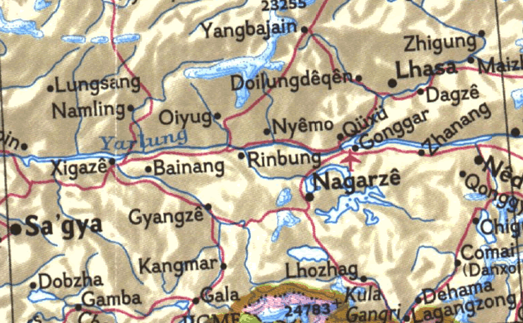
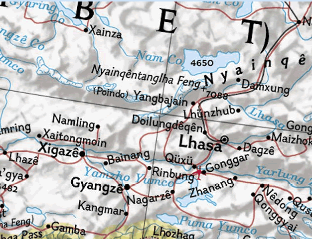
1960s NG Map Showing Non-Sinocized Place Names In Tibet
Image:nationalgeographic
1970s NG Map Showing Non-Sinocized Place Names In Tibet
Image:nationalgeographic
1980 NG Map Now Showing Tibetan Place Names In Sinocized Style
Image:nationalgeographic
1994 NG Map Shows Sinocised Place Names In Tibet
Image:nationalgeographic
Current NG Map Showing Fully Chinese Versions Of Tibetan Place Names
Image:nationalgeographic
Following many years of presenting Tibet on its maps with non-Chinese variants of Tibetan place names, by 1980 people had noticed that NG had approved the use of Chinese-sounding names, with romanized renderings of Tibetan names cleared from its maps, replaced by Sinocized versions. An act which supported the bogus claim that Tibet was part of Chinese territory. Given the eminent position of NG within the academic, map-making and geographic community it was not long before other cartographers followed suit in endorsing, through maps and atlases, China’s propaganda assertions concerning Tibet’s territorial status.
Mapping Cold-War Politics
Yet National Geographic’s Map Policy assures the public that its cartography “strives to be apolitical” that being so how does its Map Committee explain its ready compliance and conformity in 1977, to what was a clear political agenda being engineered within the United Nations. One that sought to normalize relations with China, which had that year witnessed the end of Chairman Mao’s ‘revolutionary era’? National Geographic’s decision to use Chinese versions of traditional Tibetan place names seems to have been taken following a Resolution by the United Nations Conference on the Standardization of Geographical Names in August of that same year. Which “recognized the Scheme for a Chinese Phonetic Alphabet (Pinyin) as China’s official Roman alphabet scheme and recommended the alphabet as the international system for the romanization of Chinese sic] geographical names.” (United Nations resolution III/8 1977) See here for more info http://www.eki.ee/wgrs/rom1_bo.htm
The world at that time, and particularly the United States, then still engaged in a cold-war wrestle with the Soviet Union was actively interested in reaching out to China; so long in ideological isolation during Mao’s insane revolutionary period, normalization of relations with Beijing was a prime issue within the US State Department. So much so that the very month the United Nations decided to agree to wipe Tibetan place names from the world map (an act which surely had political connections to the diplomatic and strategic objectives of the United States regarding China) then Secretary of State Cyrus Vance was dispatched to Beijing to further nurture relations with the Chinese regime.
It is no coincidence that the UN decided to adopt Pin Yin (romanised version of mandarin Chinese) as “the international system for the romanization of Chinese geographical names,”. Nor was it an apolitical action, but a calculated political act that sought to appease China. Within that context, and against the political currents that circulated at the time the National Geographic’s claim that is simply acting in accord with a UN Resolution could be seen by some as a self-serving duplicity. Whatever the case, its decision to wipe away romanized Tibetan place-names and use Chinese variants , cannot be reasonably be argued to be an action absent of politics, and certainly invites questions about the stated apolitical objectives of its Map Policy.
Furthermore, its decision and subsequent re-drafting of maps and atlases, must we imagine have occurred with the encouragement, cooperation and collaboration of China’s regime, which itself surely constitutes a political action on the part of National Geographic? Some may argue that the respected journal was simply reflecting a political reality, well if that was so why, given Tibet was illegally annexed in 1950 and subsequently came under the military and political tyranny of China, did National Geographic continue for nearly thirty years to accurately represent authentic Tibetan place names on its maps?
The political facts were that Tibet had been occupied for decades, yet to its credit NG had rightly followed a policy that featured Tibetan place names, those circumstances had not changed. Was it purely coincidental that around 1980 China was beginning to open its doors to greater academic and economic contact with the West? Did the prospect of engagement with China, and the no doubt alluring academic, career and financial benefits, prove an irresistible determinant? Whatever the facts, in deciding to produce maps that show Tibet and its settlements with Chinese-sounding names surely benefits China’s propaganda aims, to persuade the world of the supposed legitimacy of its claims over Tibet.
We would urge National Geographic to urgently reassess its current presentation of place-names in Tibet and revert to a more neutral, politically balanced Romanised Tibetan version, rather than the politically motivated Chinese versions, which of course are the fabrication of China’s regime. As NG places such importance on balance and objectivity and strives to avoid political bias, surely Romanised Tibetan place names are less controversial and also more accurate in terms of the cultural, ethnological and historic reality of towns and villages in Tibet.
ONLINE ACTION
It is surely time to put Tibet back on the world map, minus China’s poisonous distortions, if you agree please help us by emailing National Geographic and asking them to restore Tibet and authentic Tibetan place names on its maps and atlases. They may be contacted here: maps@ngs.org
NB: Map extracts here are for educational purposes to supplement written content.


This is the answer I kindly received from NAtional Geographic after my inquire about Tibets names on maps.
Thank you
MAY 06, 2014 | 02:55PM EDT
National Geographic replied:
Thank you for contacting the National Geographic Society.
On maps, geographic names—known as toponyms—serve not only as indicators of location but can be powerful symbols of independence and national pride. Discord over such names often stems from legacies of colonialism and nationalism. Regardless of where justice may exist, the colors, lines, and place-names on our maps indicate de facto status of countries or territories at the time of printing. Recently, we have received a few queries regarding our Tibetan place-names policy.
The use of Tibetan place-names on our maps has evolved over time. Until the 1970s, our maps generally displayed traditional romanized Tibetan place-names followed by their romanized Chinese names in parentheses. However, at the Third United Nations Conference on the Standardization of Geographical Names in August 1977, delegates voted on and adopted that Pinyin (a newer romanized form of the Chinese written language) be recognized as the official spelling system for place-names in China. Since the international adoption of this system, most if not all place-names in Tibet have changed to the Pinyin system.Whether the change of traditional romanized Tibetan place-names to Pinyin on our maps might be unrecognized or considered illegal by some, the fact remains that this region is presently administered by China. National Geographic does not purport to be the arbiter or determiner of Tibetan place-names, but simply tries to provide our maps with sufficient information by which this region’s current geopolitical reality can be presented.
Juan José Valdés
The Geographer
Director of Editorial and Research
National Geographic Maps
Daniela thank you so very much for taking that action, your solidarity is greatly appreciated. In challenging National Geographic (NG) on this matter you, and everyone else opposing the eradication of Tibet from the world map, are helping expose a very important truth, that Tibet, despite the self-serving excuses and justifications offered up by NG, is in reality not a part of China (as claimed by Mr Valdés) but a land invaded by and illegally occupied by China. That is the ‘geopolitical reality’ which NG is shamefully evading in its ongoing appeasement of China. Perhaps National Geographic would care to explain, since it obviously values representing on its maps “de-facto status” of countries why its maps of 1940-44 did not show France as part of Germany?